
INTRODUCTION TO GIS AND REMOTE SENSING (MARCH 2021)

INTRODUCTION TO GIS AND REMOTE SENSING (JANUARY 2021)
January 19, 2021
Zimgeo GIS & Remote Sensing Bootcamp (March to April 2023)
February 7, 2023
Course Outline and Objectives :
Aims :
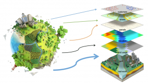
The course will introduce the main concepts in GIS and Remote Sensing. The introductory part gives a theoretical and practical grounding into aspects of Geographic Information systems and Remote Sensing. The course will be a combination of theory and practicals.
The outcomes
By the end of the conference students should be able to:
• Define and appreciate the utility of Geographic Information Systems (GIS)
• Describe the various key concepts undertaken under Geographic Information systems.
• Use GIS software to map different phenomena
• Acquire different data sets using remote sensing (data collection)
• Appreciate the methods of data collection in the field
• Perform Data analysis and mapping in a GIS
Assumed knowledge
Basic digital literacy is needed to complete the practicals
Requirements of the course
• Dual core laptops or desktop computers
• Internet connection to download satellite images
• GIS software’s
Nb: Some open software’s will be provided together with this tutorial
Course Outline :
• Principles of Geographic Information Systems and Remote Sensing Overview
• Remote Sensing Concept
• Components in Remote Sensing
• Types of Remote Sensing
• Coordinate Systems and Map Projections
• The Global Positioning Systems (GPS) for data collection
• Principles of Geo-referencing and Methods of digitizing data.
• Map Design
• Types and Uses of Satellites
• Spatial Analysis in a GIS